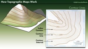
Contour Interval its usages and Calculation
This is the best way to familiarize yourself with the concept of contour intervals and contour lines are to study the legend of the world map, which tells you how far apart adjacent vertical feet or meters contour lines. This might be a number convenient to both the reality of the local terrain and math (such as 10 meters, 30 or 40 feet).

If you look at the world map itself, you’ll see that some contour lines are darker than others and are often labelled with numbers corresponding to the elevation in meters or feet. Thus, allows you contour intervals to find a reference elevation of a spot on the map near or within the area you’ll explore. After all, knowing how flat or steep a place is gives only part of the story; you probably want to know how low or high you are in absolute terms, too.
Contour Lines in Detail
They have several features in common regardless of the land. But their importance without a formal explanation or you may not appreciate them. Although some look that evident.
Contour lines have the following universal characteristics:
- Contour lines never cross each other, split or divide.
- Nearly spaced contour lines represent steeper slopes, while spaced far apart lines depict gentler declines and inclines.
- They create upward trends in the form of a V- or a U-shape at stream crossings and sides of valleys.
Index Contours
The dark labelled lines are called index contours because index contour aims to tell you an exact elevation at a precise point in spaces between the two contour indexes, allowing you to work outward, and thus downward or upward, from there. The associated elevations height usually end in 0.00 for convenience, although on metric maps, they sometimes end in 4 or 5.

For example, a topographical map of an area near Islamabad might have index contours of 1000 meters to 2000 meters and so on with a contour interval of 10 meters. This means that there would be ten “spaces” and 9 non-index contour lines between each index contour.
Calculation of Contour Intervals
A contour map legend usually identifies the contour interval on the map but sometimes available on only part of a map.
So how to calculate the contour interval becomes a useful skill.
On most maps, each fifth contour line, shown as a darker line or a heavier, is an index contour or an index line. Therefore, these index lines will be marked with index line elevation.

Find the index lines elevations of two adjacent. The highest number shows the uphill rise in the index line. Next, find the difference between the two elevations or depths.
Example,
For example, the uphill elevation is equal to 10000 feet above average sea level, and the lowest elevation is equal to 8000 feet above average sea level. Therefore, the elevation difference is equal to 2000 feet.
So how to calculate the contour interval becomes a useful skill for the contour line. But, first, start counting the contour lines from the first index line to the next index line, counting steps similarly by step.
World Maps generally count five contour lines from one index line to the next index line, with the next index line.
As with counting from one number to the next number,
like from one to 10,
the index line start with the next line,
The Counting each contour line up to and the next index line with including.
To find the interval between the contour lines of elevation,
Divide the difference elevation between the index lines by contour lines from one index line to the next index line.
In the above example, the distance 2000 is divided by the number of lines, 10.
The contour interval is equal to 2000 / 10 = 200 feet
or 200 feet unit contour intervals.
If, on the other hand, the difference between the elevation index lines were 1000 feet,
the contour interval would be 1000 / 5 = 200 or a 200 feet unit contour interval distance.
Uses of Contour Intervals in Surveying
When find a large area is to be mapped onto a small piece of paper, the contour intervals are used in surveying. A small contour interval for a small area and a higher contour interval is used for a large area.
If you find earthwork estimates for any type of structure, such as dams, roads, and bridges, can be found with the help of contour intervals on a co
We Love Cricket